High-Precision GNSS: RTK and DGNSS Solutions for IoT
November 11, 2025
Estimated reading time: 5 minutes

Numerous IoT devices rely on global navigation satellite systems (GNSS) for efficient operation. Standard GNSS is accurate within a range of 3 to 5 meters.
Many use cases require precise submeter positioning even below 10 centimeters. Techniques developed to increase GNSS accuracy include differential GNSS (DGNSS) and real-time kinematic (RTK) positioning.
DGNSS verifies and corrects satellite signals in real time. It uses regional augmentation systems to increase precision. This includes a satellite-based augmentation system (SBAS) for coarse DGNSS improvement, or for higher performance, a network of base stations with a modeled correction. These correctional adjustments increase accuracy up to a submeter level.
Among differential techniques, RTK calculates corrections based on geographical reference points with known locations to boost precision. The size and quality of data increase compared to standard DGNSS. While RTK requires a significant amount of data throughput to the module, this provides a typical accuracy of 2 or 3 centimeters.
GNSS signals distort as they travel through Earth’s ionosphere and troposphere. Atmospheric conditions, such as solar flares, further interrupt and interfere with GNSS signals.
Swift Navigation, a company specializing in precise positioning solutions, monitors distortions and models errors in its cloud-based platform in real time. It sends on-demand corrections to the devices and provides precise positioning as a software service. This solution integrates with Telit Cinterion’s compact multifrequency, multi-constellation positioning GNSS receivers:
The SE868SY-D and SE868K5-D are improved precision GNSS receivers. They support the latest generation of DGNSS corrections (RTCM 3) for reliable submeter accuracy, even in tough environments.
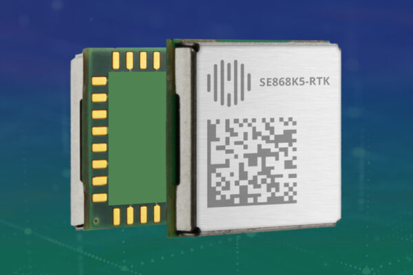
The SE868K5-RTK integrates RTK technology to provide centimeter-level accuracy. An evolution of the SE868K5-D, this module offers optimal immunity for seamless operation near cellular or other radio frequencies.
Telit Cinterion’s GNSS receivers and cellular modules work together seamlessly. They provide high-precision accuracy for IoT applications when combined with Swift Navigation’s Skylark cloud-based GNSS correction services, or when using the GNSS module as a base.
The GNSS receiver, paired with a cellular module, sends GPS and GNSS position fix data to Swift Navigation’s Skylark™ Precise Positioning Service. The service provides location-based corrections, which create an accurate position fix at the submeter or centimeter level.

Learn more about Swift Navigation’s Skylark Precise Positioning Service.
RTK uses code-phase and carrier-phase corrections, with carrier-phase measurements offering precision that is two orders of magnitude greater than code-phase. This makes RTK significantly more accurate, down to the centimeter level, while DGNSS typically provides submeter-level accuracy.
However, RTK requires a clear, stable signal to maintain a positional fix. DGNSS offers a more robust solution in environments with signal degradation.
High-precision GNSS location has potential uses across various industries, such as:
Data and power consumption requirements depend on the use case. If the application requires 24/7 module tracking and constant RTK corrections, data throughput may exceed a gigabyte per month.
An asset tracking tag that reports a few times per day is more efficient. It may consume a few hundred kilobytes of data per month.
RTK module SE868K5-RTK (68-74 mW) uses slightly more power than the DGNSS-capable modules SE868SY-D (68-47 mW) and SE868K5-D (54-59 mW). The use case and frequency of check-ins have an impact. When combined with cellular, most power consumption is attributed to the LTE connection (one order of magnitude or more).
Higher accuracy increases power consumption and data usage. IoT solution designers should strive to balance accuracy and cost-efficiency.
Several real-world test cases demonstrate the precision of the Telit Cinterion and Swift Navigation combined solution.
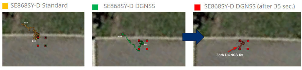
In the test case in the above pictures, the 1-meter square represents an e-scooter parking lot. The first image illustrates how the use of dual frequency (L1+L5) enables the SE868SY-D to obtain a position precisely outside the reference square. It achieves an average accuracy of ~1 m in a short time.
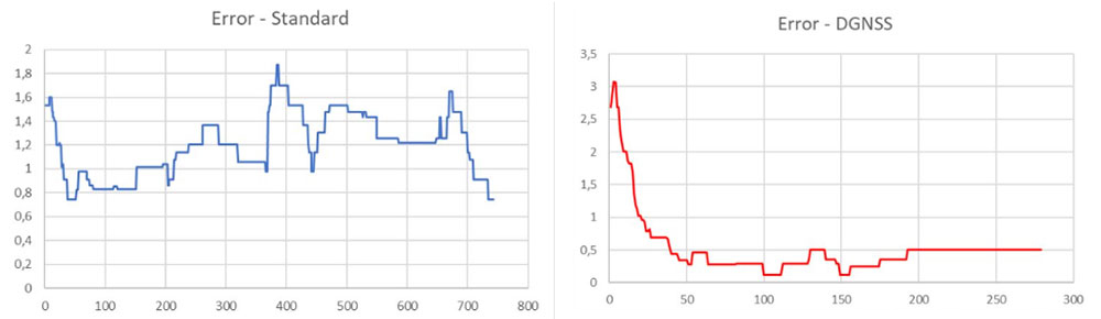
Next, the SE868SY-D was provided with corrections from Skylark Dx, Swift Navigation’s DGNSS service. With these DGNSS corrections, the module enters and maintains accuracy within 1 meter just after 35 to 40 seconds. Under optimal conditions, the module would produce accurate results even faster.
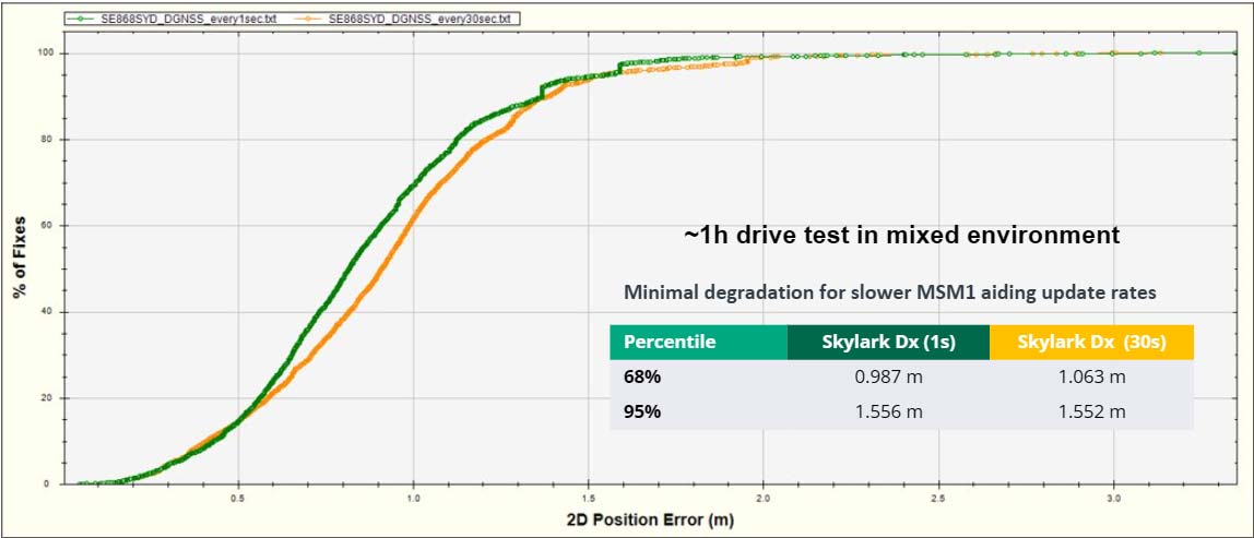
Another case tested the SE868SY-D under a foliage canopy in an urban area. With DGNSS corrections, the module provided consistent accuracy even at lower update rates and in challenging environments.
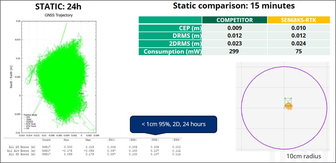
A test of the SE868K5-RTK demonstrated two-dimensional location accuracy of less than 1 centimeter over 24 hours. With RTK corrections from Swift’s RTK Skylark variant: Skylark Nx RTK, the module achieved comparable accuracy in 1 to 2 centimeters within 15 minutes. This rivals the most advanced modules on the market while operating at a fraction of the power consumption and cost.
The SE868K5-RTK, SE868K5-D and SE868SY-D all have the same compact 11 x 11 mm footprint. IoT device designers can create a single printed circuit board and install either module based on use case and deployment needs. Hence, a single design enables two augmented performance levels:
These Telit Cinterion modules process corrections in the Radio Technical Commission for Maritime Services (RTCM) format. To properly receive such data, the TelitView© SW tool and Telit Cinterion modems integrate a Networked Transport of RTCM via Internet Protocol (NTRIP) client application. This utility enables rapid evaluation of GNSS receivers with injected corrections.
Learn more about this low-risk, prevalidated solution to accelerate your time to market for location-dependent IoT devices. Contact us for a project review or a developer kit.